Blake Sea is a Continent located at Coordinates 1134-1153/1041-1060, Grid Sector K10. It is almost entirely private-owned, except for the Transcontinental Channels that link it with Nautilus.

Blake Sea in 2023,
Click on image for full resolution (5,632×6,656)
Blake Sea is composed by a lot of sea sims, with tropical islands or compleatly covered with water. Since waterways have no ban lines, Blake Sea is a paradise for sailing. The Second Norway community has developed several transportation ways: an airport that covers a whole sim, a railway and a network of surface and underwater roads.
A 2018 map of the Blake Sea and the surrounding area highlighting points of interest is available by Atlan Bade.
SLGI team gave this continent the transitory name C015.
History[]
The sailing sims were formed probably in 2008, but in 2009 they were connected with Nautilus. This was the first private - public partnership in Second Life, in early 2009 [1]. In the same time, Linden Lab was planning a new connection between Nautilus and Satori [2]. More historical information here.
Some time before 2023, Linden Lab took over many of the regions in the area marked "Blake Sea" in the map above; a database check indeed showed that all regions whose names begin with "Blake Sea -" are Linden-owned and classified as "Mainland": A total of 44 "Mainland / Homestead" regions, and 4 "Mainland / Full Region" regions, all part of the "mainland" estate.
Continent Controversal[]
Blake Sea is linked to Nautilus and has a visible separation. It growed slowly and new estates helped to this expansion. Even if some people don't recognise Blake Sea as a distinct continent, it is large enough (more then 30 sims), has a clear separation (a transcontinental channel) and all the sims share common Geography and transportation ways.
From a strict Geographic point of view, Blake Sea is composed of all sims placed East to the Nautilus - Blake Sea transcontinental channel (see Transcontinental Channels for more info). This is the largest of all intercontinental connections, but still sharp enough to allow a visible Geographical border between Blake Sea and Nautilus - Satori supercontinent. That means that Blake Sea is entirely private-owned and no mainland sim can be found inside it. If we admit this border, then it means that some water sims ownedd by Blake Sea estate are out of Blake Sea borders.
Geographical borders are drawn by nature obstacles and not by state borders. A good example is the following one: Hawaii islands belong to the United states; but Hawaii Islands are in Pacific Ocean and not in North-American continent, even if they under American government. This is also the case with Blake Sea sims West to the transcontinental channel; they are owned by the Blake Sea estate, even if they are, technically, in Nautilus.
Many parcels far outside of Blake Sea share the name of the continent (and even they use visible marks from air with the Blake Sea name). They are on mainland, in places that historically belong to Nautilus and Satori continent. They cannot be included in Blake Sea. From a Geograph, these parcels create a part, even a Subcontinent on South-East Nautilus or North-East Satori, under Blake Sea economic influence. Economic domination is taken from real life to Second Life here.
Geography[]
Blake Sea is composed of a big number of islands, owned by different estates. Majority of these islands are located inside a single sim, while some of them are placed on multiple sims. There are not two identical islands, each one is different. Ground texture is different from a group of islands to another. In many situations, each estate designed its own textures. There are many sandy islands, but also many of them are covered with grass. Vegetation is also different. And it is logical to be that way. Majority of the islands are tropical-themed, so they have palm trees and many other tropical plants on them. In other places, like Second Norway, vegetation is different.
The largest island is in Honah Lee sims. It also hosts a central mountain range.
There are many submerged sims. They form a long navigable channel oriented East-West. They are the most important navigation route and are continued in Nautilus. Near the transcontinental channel (see Transcontinental Channels, there are many submerged sims.
Altitude[]
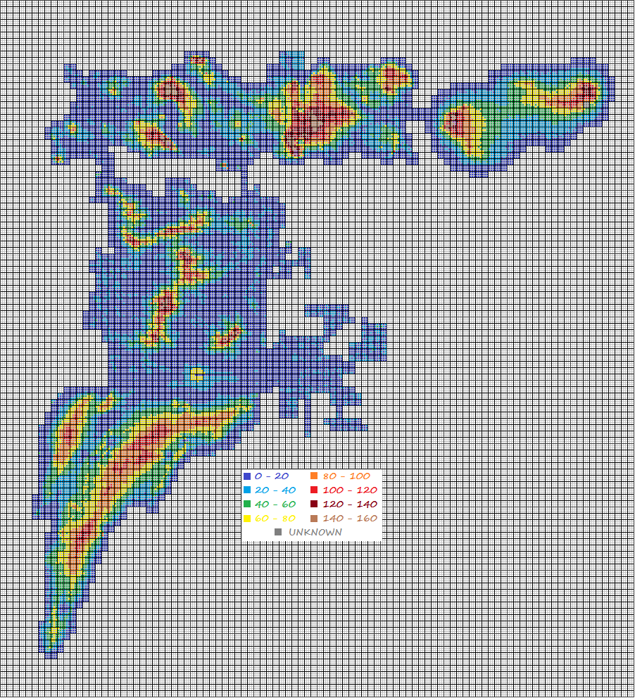
Altitude map
As seen in the Altitude map, Blake Sea is composed of a large number of islands, with low altitudes. The highest points (above 40 meters) are in Second Norwey sims and in Honah Lee sims.
The altitude map found that altitudes are usually low, below 40 meters. There are also many low islands, only a few meters above sea level, but still below 20 meters.
Note: Thanks to an entity orb teleporter in Nautilus, our drone was teleported 2 sims away. That caused an error and Blake Sea was pushed 2 sims to East on map. The map is correct for the entire Blake Sea, except that the border sims of Nautilus appeared 3 times.
Airport SNO is the only sim without water. Altitude map shows that in fact water level is set to zero. If water level would be set to default value, the entire sim should be flooded.
Transportation and accesibility[]

Blake Sea Waterways


Second Norway road & railway
Main transportation way is by water. There are no borders for navigation. Road transportation is limited to some parcels, while in Second Norway, there is the fastest railway in Second Life: Second Norway Railway. Air transportation is also important, since there are many airports and Airport SNO is the largest of all airports.
Our team detected no entity orb teleporter. Ban lines, if they exist, they are rare.
Blake Sea has only a limited road & rail network inside Second Norway. Additional data can be found on List Of Roads, List Of Railways and on List Of Waterways.
Road network:                  6.74 km
Paths:                         2.00 km
Railway network:               3.42 km (in construction)
Second Norway surface:         1.64 square km 4.617
Blake Sea surface:             9.09 square km
Road network efficiency: 5.666 for Second Norway, 1.022 for entire Blake Sea
Rail network efficiency: 2.815 for Second Norway, 0.508 for entire Blake Sea
Waterway Efficiency Indes is found to be the highest of all private-owned continents: 19.680
Ground transportation efficiency: 8.481 for Second Norway, 1.530 for entire Blake Sea
This means a total infrastructure efficiency of 21.210.
Coordinates[]
Coordinates are shown in sims, like those from Gridsurvey [3]. First numbers indicate longitude (min and max), while the last numbers indicate latitude (min and max). Note: The names are not official.
- Common coordinates: 1134-1153/1041-1060
- Blake Sea sims: 1134-1147/1048-1053
- Balboa sims: 1137-1147/1051-1056
- North Blake Sea: 1143-1148/1152/1160
- Second Norway: 1148-1153/1052-1058
- South Blake Sea: 1143-1148/1152-1160
- Galaxy sims: 1141-1141/1041-1047
- Honah Lee sims: 1136-1140/1041-1047
Statistics[]
- Number of sims: 121 (wide:20/19)
- Size in km: 9.90 square km (wide:5.12/4.68)
- Complete flooded sims: 28
- Complete dryland sims: 1 (Airport SNO)
- Coast sims (water access): 92
- Ground transportation: about 20 sims with roads and 7 with railway (Second Norway)
- Sims wothout direct access (water, road): 0
- Population density: med-high
Inside Blake Sea[]
- B110 - Balboa
- B116 - Blake Battle Sims
- B115 - Blake Deep Sea
- B109 - Blake Passage Estate
- B108 - Blake Sea Passage
- B118 - Blake Void
- B107 - Central Blake Sea
- B117 - Honah Lee
- B119 - Large Blake Islands
- B111 - New England Islands
- B114 - Sailors Cove
- B113 - Second Norway
- B112 - Snug Harbor
- Brigantine Island, inside Blake Sea - Brigantine.
- Crows Nest, inside Blake Sea - Crows Nest.
- Half Hitch, inside Blake Sea - Half Hitch.
- Indian Islands, inside Blake Sea - Indian.
- Kraken Islands, inside Blake Sea - Kraken.
- Lanyard Island, inside Blake Sea - Lanyard.
- Sirens Isle, inside Blake Sea - Sirens Isle.
- Spyglass Island, inside Blake Sea - Spyglass.
- Travertine Island, inside Blake Sea - Travertine.
- Turnbuckle Islands, inside Blake Sea - Turnbuckle.
- Windlass, inside Blake Sea - Windlass.